Geomatics > Services > Digital Image Processing (DIP)
Adroitec has a varied experience on applying various High end DIP techniques for Natural Resource Mapping/ Targeting / Management/ FM/ Thematic Mapping etc. using Multisensor and Multitemporal High to Very High Spatial Resolution Remotely sensed data.
HR and VHR Image based information is a critical tool for
 Managing World’s Resources
Flora and Fauna/bio-spheres
Land Management
Facility Management
Temporal, accurate & visual coverage of the terrain
Adroitec has acquired expertise in handling datasets from these Sensors and are
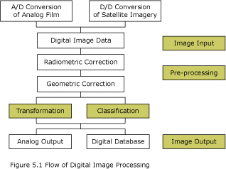
capable in TURNKEY SOLUTIONS to derive SIM’s, VARSEP’s, Thematic Maps, DTM’s and applying DIP techniques for the updation of Thematic Information using RS data in VISIBLE and MICROWAVE Range.
Adroitec’s expertise is available for
Multi-sensor data fusion for FM/ Resource Mapping
IRS LISS-III + PAN fusion to derive 1:12500 scale SIM’s
RS and GIS Resource Modelling
SSPM based Risk Maps
Thematic extraction (Land use/landcover, Geology, Structure, soil,
 Geomorphology, drainage morphology, watershed, vegetation & biomass).
Digital Supervised Classification for Resource Mapping
Natural Hazard Management
Resource targeting (ground water, minerals/gossan etc.)
Change detection studies using Multitemporal & Multisensor platforms
Large scale Urban Planning Maps (IKONOS at 1:3400) and IRS (1:12500)
DTM based Route Alignments & planning Maps for FM
VR based 3D data extraction/ plans
Adroitec’s Deliverables (Digital / hardcopies)
Georeferenced Seamless mosaiced Satellite Image Maps from 1:250,000 to
1:3400 scale
DTM’s on 1:4000 scale to 1 * 1 Quads
Thematic Maps with graphical layouts
Georesource Utility Maps (GUM)